Showing posts with label south east asian. Show all posts

Borobudur

Borobudur
Borobudur

Borobudur, the largest Buddhist monument in the world, is located in central Java. Surrounded by fertile rice fields and coconut plantations, the Buddhist stupa is located on a small hill above Kedu Plain.

It was built in 760 to resemble a mountain and was completed in 830. Borobudur is associated with two Buddhist powers—the Sanjaya rulers and the Sailendra dynasty—which displaced the Sanjayas in 780, though the latter regained power in 850. The monument is made from more than a million blocks of stone, each weighing about 100 kilograms. These stones were arduously carried up a hill from a nearby riverbed.

These blocks of stone were then cut and carved by skilled Javanese craftsmen to form rich artistic depictions of stories familiar to Buddhist pilgrims. These bas-relief panels relate ancient fables, fairytales, and the life of Gautama Buddha. The panel reliefs were based on earlier Tantric designs.


The complex meaning of Borobudur is found in deciphering the architecture and the reliefs carved into stone. Borobudur yields multiple layers of meaning rather than one single concept, although the skilful builders managed to combine different elements into a harmonious whole.

The impressive structure was built in the Mahayana tradition of Buddhism, which focuses on the personal, solitary, ascetic journey to achieve Nirvana. Ancient pilgrims made their way up the stupa to attain spiritual merit. Borobudur has a simple structure, consisting of a series of concentric terraces.

An aerial view reveals that the Borobudur temple is actually a large mandala, often employed to initiate Buddhists into higher levels of consciousness and spiritual power. As Buddhist pilgrims progress upwards, they are moving through increasingly higher planes of consciousness, with the aim of ultimately attaining Nirvana. In order to achieve enlightenment, pilgrims had to make 10 rounds in the monument.

Borobudur and the surrounding environtment

At the summit, there is a large stupa surrounded by 72 smaller stupas. Built to visually stimulate, Borobudur enables pilgrims to forget the outside world, as the visitor walks through enclosed galleries. On the round terraces the pilgrim witnesses a view of surrounding green fields, feeling a sense of elation symbolizing enlightenment, the ultimate aim of such a pilgrimage.

The awesome structure of Borobudur provides Buddhist pilgrims with physical space to achieve spiritual enlightenment as they pass through 10 stages of development. It was a place to achieve the practical end of becoming a bodhisattva, an exalted being who is actively seeking enlightenment.

Aerial view of Borobudur

Burma

Burma
Burma

The classical civilization of Burma (Myanmar) is centered at Pagan. After the collapse of the Pyu state, the Mrammas (Sanskritized Brahma), or Burmans, founded their chief city, Pagan (Arimarddanapura or “City Where Enemies Were Exterminated”) around 849 c.e. The ethnic Chinese had pushed them back around the second millennium b.c.e. from Northwest China to eastern Tibet, after which they moved to Myanmar over several centuries.

The first Burman center developed in the rice-growing Kyawkse Plain at the confluence of the Irrawaddy and Chindwin Rivers. According to the local chronicles, Pagan began as a group of 19 villages, each having its nat, or local spirit, which were later fused into a cult of a common spirit. Burmese legends speak of intrigue and bloodshed in the early Pagan history until the emergence of King Anawratha, or Aniruddha (1044–77).

Aniruddha conquered the Mon country of Thaton in 1057 c.e., resulting in an infusion of Mon culture into Pagan. He maintained friendly contact with King Vijayabahu of Sri Lanka. The Cola ruler Kulottunga I was threatening the latter. Vijayabahu asked for help from the Pagan king, who sent military supplies. Sri Lanka’s king sent Aniruddha the tooth relic of Buddha, which was enshrined in the Shwezigon Pagoda. Pagan was brought into the maritime trading network linked to the eastern coast of India.


Along with the Mon monk and scholar Shin Arhan, Aniruddha was responsible for spreading Hinayana Buddhism among his people. This quickly spread all over Myanmar and eventually to mainland Southeast Asia. Aniruddha also is credited with constructing a large number of pagodas, including the Shwezigon Pagoda. He visited the Bengal region and married an Indian princess. Aniruddha developed the small principality of Pagan into an extensive kingdom, and a distinct Burmese civilization grew based on Mon literature, script, art, and architecture.

The second prominent king of Pagan was Thileuin Man (Kyanzittha), who ruled from 1084 to 1112. He crushed the Mon uprising that had claimed the life of the earlier king’s son and successor, Man Lulan, and made peace with the rival Thaton faction of the Mons through matrimonial alliances.

The Thervada monkhood flourished under his patronage. He even fed eight Indian monks daily for three months. Having heard about Buddhist monuments like the famous Ananta Temple in the Udayagiri hills of Orissa, he constructed the magnificent Ananda Temple in imitation. Kyanzittha also visited Bodhgaya and helped repair Buddhist shrines.

He tried to bring assimilation of different cultural traditions prevalent in Myanmar, and the Myazedi pillar of 1113 c.e. had identical inscriptions in four languages: Burmese, Pali, Pyu, and Mon. He sent a mission to China, which recognized the sovereignty of Pagan.

The transition from Mon to Burman culture occurred during the rule of the grandson of Kyanzittha, Alaungsithu (Cansu I), who had a long reign from 1112 to 1165. He undertook punitive expeditions to Arakan and Tenasserim. Relations with Sri Lanka deteriorated over interference with trade between Angkor and Sri Lanka. Alaungsithu nurtured Buddhism and completed the imposing Thatpinnyu Temple in 1144.

The last of the important kings of Myanmar was Narapatisithu (Cansu II, 1174–1211), who ended the Mon influence in the Pagan court. Relations with Sri Lanka improved, resulting in the end of the friendship of Burmans with Colas and a promise of noninterference by Pagan in Sri Lanka’s trade over the isthmus region. The king also introduced reforms in monkhood. However his successors were unsuccessful, and gradual deterioration started in the Pagan kingdom.

The shrinking of central authority resulted in Arakan and Pegu becoming independent. The Thai people known as Shans began to enter Pagan. There were also subsequent Mongol expeditions against the kingdom. The last king of the dynasty, Narasimhapati (Cansu IV), was a boastful ruler, and his subjects murdered him for his flight during a Mongol invasion.

Under the leadership of the Shans, the kings of Pagan were forced into a ceremonial role only. The problem facing Myanmar had been to hold together different ethnic groups, and this was evident in the Toungoot (Tungut) dynasty of the 16th century and the Konbaung dynasty (1792–1885).

The prevalence of Sanskritized names and commercial relations point to the close link between India and Myanmar. The region was geographically nearest to India among Southeast Asian countries, and there were land and sea routes through which cultural relations developed.

From very early on Indians traveled these routes to Southeast Asia. Cultural intercourse between the two regions grew, probably through traders and Buddhist missionaries reaching lower Myanmar. Adopting Indian practices, women were given a higher place in society, and the caste system was rejected.

Though Buddhism dominated daily life, it was mingled with Brahmanism. At the site of King Kyanzittha’s palace, naga spirits were propitiated, and the services of Brahmans were required. The king was proclaimed an avatar (incarnation) of Vishnu after his death. The name of one of the early cities of the Pyu people was Visnupura (modern Beikthano), and it was a center of Vishnuite influence.

Images of Brahmanical gods such as Vishnu, Brahma, and Shiva are found throughout Myanmar. Compared to Brahmanism, the influence of Buddhism in Myanmar was greater. In the Buddhist Jatakas there are frequent references to the sea voyage to Suvarnabhumi, or the golden land, which has been identified with Myanmar. Kings like Aniruddha and Kyanzittha were patrons of Buddhism, and because of their endeavor, the religion took firm roots in Myanmar.

Champa Kingdom

Champa Kingdom
Champa Kingdom

According to Chinese texts, in 192 c.e., Champa was formed during the aftermath of the breakup of the Han dynasty of China. The Champa kingdom was situated along the coastal plains of present-day central and southern Vietnam. The Chams shared many biological traits with the Malays and Polynesians.

After years of fighting with rival Chinese factions in Tonkin, the Chams came to be under Indian cultural influence. Elements of Indian culture formed a huge part of Cham culture, as a result. The Champa kingdom was divided into four regions with Hindu names—Amaravati, Vijaya, Kauthara, and Panduranga.

The four, which were already powerful, were reunited under King Bhadravarman in 400. Located between India and China, the Chams were in a strategic position to conduct trade between West and East Asia. The kingdom played a key role along this trade route, which became known as the Silk Route of the Sea. At the height of their success, they became a prosperous seafaring power that actively participated in commerce and piracy along the coastline.


Because of its strategic location, the Chams were constantly under threat of attack from their neighbors. Cham-Chinese rivalry persisted for centuries and featured prominently in Cham history. In order to stop repeated destructive Cham raids on their coasts, the Chinese invaded Champa territory in 446. Champa was made subservient to China but by the sixth century the Chams achieved independence from China rule.

Champa trade and culture flourished during this era. Champa success was however disrupted by Javanese invasions in the eighth century, which they managed to stave off. In the ninth century under King Indravarman II, the Chams relocated their capital farther north in Amaravati. During this period, the Chams built beautiful temples and palaces, many of which survive today.

By the 10th century the Champa kingdom faced another adversary from Hanoi in the form of the Dai Viet, who wanted the territories of Amaravati and a few decades later, Vijaya. Later the Cambodians launched attacks on their kingdom, along with the Vietnamese.

Even though the Cham king Harivarman managed to fend off attacks from these two invading forces in 1145, the Khmers returned under a new more aggressive king and managed to bring Champa under his leadership. But two years later, a new Cham leader successfully defeated the Khmers. In 1177 the next Cham king even invaded the Cambodian capital of Angkor.

This victorious period was extremely brief, as the Chams were once again subjected to Cambodian rule in 1190 until 1220. The Chams would never again experience a period of resurgence and instead suffered successive invasions by foreign forces. After 1220, Vietnamese kings, who were members of the Tran dynasty, attacked Champa.

The Champa kingdom was further weakened by the Mongol invasion in 1284. By the end of the 15th century very little of the Champa kingdom was left as their territories were being conquered by foreign invaders, who completed the conquest of Cham territory during the 17th century.

Chenla

Chenla Cavalry troops

Two successive kingdoms with strong Indian influence emerged during the pre-Angkorean centuries of Khmer history. These were the Funan, from the second to sixth centuries, and Kambuja (Chenla, Zhenla in Chinese) from the sixth to the eighth centuries. A vassal state of Funan, Chenla emerged as an independent state in the middle of the sixth century. A sea route developed between India and China by this time.

The shift from the coastal trade route coincided with the appearance of conquerors from the mid-Mekong area, the brothers Bhavavarman (r. 550–600) and Mahendravarman (r. 600–611). They focused on the rice-growing areas of the Mekong basin, rather than maritime trade. The new kingdom, called Kambuja, traced its origin from the sage Kambu Svayambhuva and the daughter of Nagas, Mera.

According to the Chinese chronicle the History of Sui, Chenla was a feudatory state of Funan, covering roughly northern Cambodia and southern Laos of modern times. Its capital was at Lingaparvata with a Hindu temple dedicated to the god Bhadresvara. Chenla became a separate state after seceding from Funan in 550 with the accession of Bhadravarman I as the first ruler of the newly independent kingdom.


He was the grandson of Funanese ruler Rudravarman (r. 514–539) and had married a Chenla princess named Lakshmi, who was heir apparent to the throne. Bhadravarman became the independent king of Chenla in 550, when the ruler died. In his long reign, Chenla was engaged in warfare, and Chitrasena was in charge of the army. The kingdom of Chenla covered the whole of Cambodia, southern Thailand, Laos, and the Mekong Delta region.

Bhadravarman’s brother Chitrasena, with the title of Mahendravarman, succeeded him and ruled for 11 years. He was a brave king and conqueror. The reign of his son Isanvarman I (r. 611–635) was marked by extension of the kingdom westward, and establishment of a new capital, Isanpura at Sambor Prei Kuk (the Kompong Thom province of modern Cambodia), in 613.

Like his father, he followed a policy of friendship toward the Champa kingdom and married a Champa princess. Bhavavarman II was the next ruler (r. 635–650), who was succeeded by Jayavarman (650–690). He consolidated the Chenla kingdom. After his death, Queen Jayadevi controlled the affairs of the state. Imminent civil war led to the disintegration of the Chenla kingdom.

Chenla map
Chenla map

Factional disputes in the court resulted in the splitting of the kingdom in 706 into Land Chenla (Upper Chenla) and Water Chenla (Lower Chenla). Upper Chenla, with its capital in the Champassak province of modern Laos, was a somewhat centralized state with 30 provincial headquarters operating as administrative centers. It also sent embassies to China. Lower Chenla, occupying the former Funan kingdom along the Mekong Delta and the coast, had a turbulent existence with constant pirate raids from Java.

The minor Khmer states like Aninditapura and Sambhupura were locked in rivalry over the control of Lower Chenla. Pressure also mounted against Chenla by the Sailendra kings of Java. The last of the rulers was killed in 790 and it became a vassal state of the Sailendras. A prince from Sambhpura, who was in Java, took the reins as a puppet ruler. But Jayavarman II asserted his independence in 802, becoming the founder of great Angkorean empire that lasted until the early 15th century.

The Cambodian civilization in Chenla, like that of the Funan and Angkor periods, witnessed a good deal of Indian influence. Indian elements were mixed with indigenous myths of the Moon and serpent. Building a royal lingas (phallus symbol of Shiva) on mountains was a blending of the autochthonous mountain cult with Hindu beliefs.


Shiva in his linga form was connected with devaraja cult, which was used by Jayvarman II afterward to proclaim his sovereignty from Java. The Chenla kings were deified. Lord Shiva was worshipped under different names such as Bhadresvara, Sambhu, Girisa, and Tribhubanesvara.

Inscriptions from Cambodia attest to the prevalence of Sanskrit. Rhetorical and literary conventions were well known to writers of epigraphs in Chenla. They were also well acquainted with Indian epics, kavyas and puranas. The inscriptions refer to the Vedas, Vedantas, and Smritis.

Many Sanskrit words were absorbed into old Khmer, relating to geographical names, the names of divinities and persons, administrative terms, and terms relating to the calendar and numbers. Another Indian custom persisted in the marrying princesses to brahmans (Hindu priests). The brahmans played an important role in the religious life of the people.

The chief priest or purohita had a powerful influence on the royalty. This sacerdotal office passed from uncle to nephew in the maternal line, which was an example of an indigenous matrilineal social system. Kings sought to ally themselves to a particular priestly family by matrimonial alliance.

Buddhism was also prevalent in Chenla. The Mahayana faith came to Cambodia from Java as well as India. Buddhist statues are found at the time of Bhavavarman II. Influences from India, the megalithic culture of Southeast Asia, China, and neighboring regions in Southeast Asia enriched the culture of Chenla.

Dvaravati

Dvaravati map
Dvaravati map

The Mon kingdom of Dvaravati (also called Siam) flourished in what is now Thailand from the sixth century c.e. to around the 11th century. The kingdom covered the political area of Nakhon Pathom (west of present-day Bangkok), U-Thong, and Khu Bua.

Dvaravati extended outward from the lower Chao Phraya River valley, to the westward Tenasserim Yoma, and then southward to the Isthmus of Kra. The kingdom also consisted of towns immediately outside this perimeter that paid tribute to the kingdom, while not necessarily considering themselves under its direct rule.

Dvaravati did not yield strong political influence on other established Mon kingdoms or states such as Myanmar or the Mon in northern Thailand. This was because of its isolated geographical location (surrounded by mountainous regions). Dvaravati is considered to be the epicenter of the spread of Indian culture in the region.


The Dvaravati kingdom’s capital was Nakhon Pathom, a city archaeologists and historians believe to have been established around 3 b.c.e. Around 607 Chinese pilgrims wrote of a kingdom called To-lo-poti, which practiced Buddhism. It is widely believed that they wrote of Dvaravati.

While the name Dvaravati is of Sanskrit origins, the kingdom was only referred to as such by the Western world in 1964 when anthropologists and archaeologists found coins in the area inscribed with the words sridvaravati. The presence of coins indicates trade, and the Dvaravati kingdom was famed for its trading culture with India, and its sophisticated economic infrastructure.

The kingdom of Dvaravati actively practiced Buddhism, albeit with a mixture of indigenous Mon and Indic culture. Buddhist pilgrims belonging to Emperor Ashoka disseminated it within Southeast Asia. The kingdom was also the center of Buddhist devotion in Southeast Asia at that time.

Numerous Buddhist artifacts have been found in Dvaravati and range in style and infl uence by the trends found within the Gupta empire (Hindu elements), Theravada, and Mahayana Buddhist tradition. Various objects have been found in Nakhon Pathom that point toward ritual offerings as part of the belief structure.

The period of Dvaravati rule was greatly influenced by Vedic and Indic principles within a Buddhist framework. It maintained strong cultural and religious ties to India, reflected through the use of architecture, art, and language. Pali and Sanskrit were spoken, as was the indigenous Mon language.

Art flourished, as did intellectual pursuits such as literature and poetry. Dvaravati was a highly organized and political society and modeled itself upon the Gupta style of organization where minor princes ruled outer provinces and the king directly presided over his locality.

Dvaravati employed the use of councils and administrative regions to govern the wide area. Moats uncovered by archaeological research point toward a sophisticated system of agriculture and as such agricultural development allowed the kingdom to be relatively self-sufficient. Dvaravati was able to sustain its population for centuries.

The kingdom of Dvaravati predated the Khmers by at least 100 years; however it was eventually eclipsed and absorbed into Khmer and Thai religion and culture. Dvaravati had a tumultuous history from the 10th century onward when it was first conquered by the Burmese, and then captured by the Khmer in the 11th century, who dominated the area right up to the 13th century when it was taken over by the Thai kingdom.

Ibn Batuta

Ibn Batuta
Ibn Batuta

Ibn Batuta (also Ibn Battuta), Muhammad Ibn ‘Abd Alah, born in Tangier, Morocco, was one of the greatest Arab travelers in the 14th century. A descendant of a scholarly family that produced many judges, he was educated in Tangier. As other travelers from Morocco, he began his travels by undertaking a pilgrimage to Mecca and to centers of learning in Egypt and Syria. But he soon became restless and wished to explore other parts of the world.

For some 28 years Ibn Batuta traveled to many countries in the Islamic world, to Armenia, Georgia, the Volga region, Central Asia, Constantinople, India, the Maldives, Indonesia, parts of China, and East and West Africa. He performed his pilgrimage to Mecca four different times. It is from Ibn Batuta’s journals that we know so much of these lands in his time.

During his travels he became acquainted with sultans and rulers in many parts of the world. At times he held important positions in foreign lands and became an influential judge in Delhi during the rule of Muhammad Tughluq. He also played an important role in the Maldives. In 1353 he returned to Morocco.


At the request of the sultan he dictated his book Rihla to a writer by the name of Ibn Juzzay, who died in 1355 after having completed and edited the text. At the end of his life Ibn Batuta served as a judge in a Moroccan town and was buried in Tangier.

Since someone else wrote Ibn Batuta’s travel account, it is difficult to ascertain at times his own voice or character. It is likely that Ibn Juzzay was not altogether faithful to what he heard from his interlocutor; furthermore, one must be careful about the traveler’s memory in reconstructing past events, episodes, and dates. Ibn Batuta’s travel account is a major medieval document that sheds light on the historical, cultural, and social life in many parts of the world, particularly India, the Maldives, Asia Minor, and East and West Africa.

Khmer Kingdom

Map of Khmer Kingdom

Until 802 the Khmers were organized into a number of warring independent kingdoms. They often fought among themselves and against foreign enemies such as the Chams located in present-day central Vietnam. King Jayavarman I, also named Parameshvara posthumously, united these disparate kingdoms. He first appeared in historical sources in 709. The Khmer empire was to span most of present-day Cambodia and had vassal states in parts of Thailand, Laos, and Vietnam.

Jayavarman I, II, and III

According to text inscribed on a stela (stone or wooden slab) King Jayavarman I originated from Java, though the Malay Peninsula has also been suggested by scholars as a possible place of origin. From his initial base in Indrapura, most likely situated northeast of Phnom Penh, he launched attacks across the Mekong and on Sambhrapura, Wat Phu, and onward to Phnom Kulen, a sacred place for the Khmers, where he settled in 802.

At the time it was known as Mahendravaparta. It was here that the sacred rites were performed on Jayavarman by Brahmin priests of the Shivaite sect proclaiming him the universal monarch of the world, or chakaravartin, a rite based on Hindu tradition from India.


The system of dynastic succession within the Khmer kingdom was highly complex. Both men and women could become rulers. More importantly, kingship was passed through other family members of the same generation rather than to sons upon the death of a ruler, although there was often strong opposition to this.

The next king, Jayavarman II, was responsible for laying the spiritual foundations within the Khmer Empire. After the death of Jayavarman II in 834, Jayavarman III succeeded him. Harihalaya became his capital, southeast of Angkor. The civilization of Angkor was unique as it was a mixture of two influences—Indian and Javanese.

Indravarman I

The second king built many shrines, but the next ruler, Indravarman I, also called Isvaraloka, was credited for contributing the most to the religious environment within the Khmer empire. Indravarman laid the foundations for the now centralized Angkor state. Indravarman II ascended to the throne in 877 and ruled until 889. His period of rule was relatively peaceful, even though he succeeded in extending the borders of the Khmer Empire.

An ancestral temple, Preah Ko, was built in the imperial capital of Hariharalaya and was consecrated in 880. It was a shrine consisting of a set of six brick temples dedicated to his ancestors and past kings. The temple is considered a piece of art with beautiful male and female divine figures, structural elements such as colonnades, and other embellishments.

Another major building project was the state temple, south of the ancestral temple. This temple, known as Bakong, resembled a stepped pyramid and symbolically was regarded as a mountain. Hindu temples in the Khmer kingdom were often built as mountains as they were seen as earthly representations of the divine mountain, Mount Meru, home of the gods in Hindu mythology.

A precursor to the spectacular Angkor Wat and Angkor Thom, the temple had a complex structure and was surrounded by a huge double moat, a feature of Angkor Wat as well. At the same time Indravarman set into place a system of irrigation for cultivated rice fields. Large agricultural projects were undertaken, such as building a huge reservoir.

Yashovarman and Suryavarman II

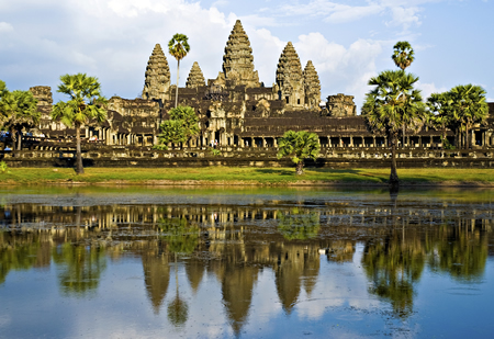
King Yashovarman, who ruled from 889 to 900, established the city of Yasodharapura (also known as Angkor) as the new capital. Between 900 and 1200 Angkor achieved great prominence because of the rise of impressive temples in Angkor, including the famous temple that became known as Angkor Wat. It was built in the 12th century during the reign of Suryavarman II. who ordered it to be built.
Angkor Wat
Angkor Wat

Suryavarman II, dubbed one of the greatest Khmer kings, was a warrior-king and launched many attacks on the Dai Viet, which was highly resilient and resisted subjugation. Suryavarman had gained the throne through the violent means of killing his great uncle, King Dharanindravarman.

The architecture of Angkor Wat is in classical Khmer style. It was also a temple-mountain surrounded by a wide moat, crossed by a causeway on the east side. The state temple was dedicated to Vishnu, whom Suryavarman II considered the Protector of the Khmer empire, a departure from earlier rulers, who regarded Shiva as the protector of their kingdom.

The 11th century witnessed a general rise in Vaisnavite thought in religious and philosophical life in India, and since travel between India and Southeast Asia was frequent, Angkor Wat could have been a reflection of the contemporary trends in Hindu philosophy. The external appearance resembles descriptions of Mount Vaikuntha, home of Vishnu.


Jayavarman VII

The city of Angkor Thom was built by another great king, Jayavarman VII, in 1181, after he defeated the Chams who had captured Angkor in 1177. Instead of reclaiming the old Khmer spirituality before the Cham defeat, Jayavarman pursued a course of reinvention. He enacted a major change in the Khmer Empire by replacing Hindu religion with Mahayana Buddhism as the official state religion.

The power of the Hindu aristocracy within the empire was seriously undermined. It is said that Jayavarman VII was following the example of Ashoka, the model for all Buddhist rulers. The imposition of Buddhist cosmology led to an extensive reworking of religious, political, and military organization within the Khmer kingdom.

Jayavarman VII was responsible for organizing the capital, Angkor Thom, into a mandala, which is a symbol of the universe and its energy. The construction of Angkor Thom, based on this highly regulated pattern, took about a decade. It was an awesome feat as the mandala was extremely difficult to replicate in the form of a city.
Bayon temple
Bayon temple

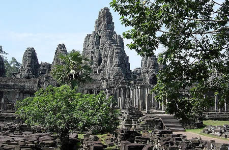
The new capital city was known as Angkor Thom Mahanagara, or simply Angkor Thom. The site of the city coincided with that of an earlier city, Yasodharapura, built more than two centuries before. Right in the middle of the city is the Bayon, the state temple built by King Jayavarman VII, in the exact center of his capital of Angkor Thom. Every road from the city gates leads directly to the Bayon.

The Bayon, which was covered in gold and orientated toward the east, according to a Chinese account, was also known as the Assembly Hall of Gods. According to the concept of the mandala, the gods would gather there on certain days. Jayavarman VII was at the peak of his reign, and he assumed supreme rule.

Indravarman II and Jayavarman VIII

The decline of Angkor began soon after Jayavarman’s death. His son, Indravarman II, who ruled from 1219 to 1243, withdrew from many provinces previously conquered from the Champa kingdom. Their neighbouring rivals, the Thais, were also gaining more power, strengthened by the establishment of the kingdom of Sukhothai.

The Khmer once again lost their hold on Thai provinces. Soon, the Thais emerged as the chief rivals of the Khmers, replacing their former enemies, the Chams. The Mongols under the leadership of General Sagatu also presented a threat to the Khmers, but the Khmer rulers were careful not to go to war against such a powerful force.

Jayavarman VIII ascended to the Khmer throne in 1243. He was a Hindu rather than a Buddhist like his immediate predecessors. He was a violent anti-Buddhist and went on to destroy many Buddhist sculptures and converted the Bayon temple into a Hindu temple. His son-in-law, Srindravarman, who usurped his throne in 1295, was a Buddhist, though he was a follower of Theravada Buddhism. Later Khmer kings were adherents of this faith.

The Thai Ayuttaya kingdom replaced the Sukothai kingdom in 1350 and succeeded in diminishing Khmer power through several attacks. By 1431 the Thais had conquered Angkor. Despite being weakened, a line of kings managed to rule from Angkor and a separate line of Khmer kings continued to rule in Phnom Penh. The latter line achieved more prominence because of the rise of Mekong as an important trade center, leading to the fall of Angkor.