Showing posts with label south america. Show all posts

Pre-Inca Civilizations in Andes

Pre-Inca Civilizations in Andes

Building on the economic, political, cultural, and ideological-religious developments that shaped Andean prehistory from the Lithic Period to the mid-Early Intermediate Period, the eight centuries between 600 and 1400 c.e. saw the continuing expansion and contraction of kingdoms, states, and empires across large swaths of the Andean highlands and adjacent coastal lowlands. The three most prominent imperial states were the Huari, the Tiwanaku, and, later, the Chimor. These empires, in turn, laid the groundwork for the explosive expansion of the Inca Empire in the 15th century.

The Tiwanaku culture and polity, whose capital city of the same name was located some 15 kilometers southeast of Lake Titicaca, traced its origins to humble beginnings around 400 b.c.e., with the establishment of clusters of residential compounds along a small river draining into the giant lake.

For the next eight centuries, the nascent Tiwanaku polity competed with numerous adjacent settlements for control over the rich and highly prized land in the Lake Titicaca basin, until the mid-300s c.e., when it came to dominate the entire basin and its hinterlands.


Lake Titicaca and its surrounding basin represent a singular feature in the mostly vertical Andean highland environment. The largest freshwater lake in South America (covering some 3,200 square miles and stretching for some 122 miles at its longest) and the highest commercially navigable lake in the world (at an elevation of 12,500 feet), Lake Titicaca tends to moderate temperature extremes throughout the basin while providing an ample supply of freshwater and a host of other material resources, especially reeds, fish, birds, and game.

The basin itself covered some 22,000 square miles, significant portions of which were relatively flat and arable when modified with raised fields. All of these features rendered the zone unusually productive and highly coveted—not altogether unlike the Basin of Mexico—permitting it to support one of the highest population densities in all the pre-Columbian Americas.

Archaeologists divide Tiwanaku’s growth into five distinct phases extending over a period of some 1,400 years, until the polity’s collapse around 1000 c.e. Phases I and II saw the settlement’s gradual expansion on the southern fringes of the lake. Phase III (c. 100–375 c.e.) saw extensive construction within the capital city.

By Phase IV (c. 375–600 or 700), Tiwanaku had emerged as a true empire, dominating the entire Titicaca Basin and extending its imperial and administrative reach into windswept puna (high plains), throughout large parts of the surrounding altiplano, and south as far northern Chile.

Phase V (c. 600/700–1000) was a period of gradual decline, until the capital city itself was abandoned by around 1000. The empire’s economic foundations were agropastoral, combining intensive and extensive agriculture with highland pastoralism.

The dominant feature of the capital city, a structure called the Akapana, consisted of an enormous stone platform measuring some 200 meters on a side and rising some 15 meters high. Evidently the ritual and ceremonial center of the city and empire, the flat summit of the Akapana held a sunken court with elaborate terraces and retaining walls in a style reminiscent of Chiripa and other Titicaca sites.

A nearby structure, called Kalasasaya, prominently displayed the famous Gateway of the Sun, chiseled from a single block of stone and featuring the so-called Gateway God, which some scholars interpret as a solar deity.

A host of other buildings, walls, compounds, enclosures, and platforms graced the sprawling urban center, which housed an estimated 20,000 to 30,000 inhabitants. Like other Andean cities, Tiwanaku had no markets, its goods and services exchanged through complex webs of kinship networks and state-administered redistribution.

Covering a much larger territory than Tiwanaku was the Huari Empire, with its capital city Huari on the summit of Cerro Baul some 25 kilometers north of the present-day city of Ayacucho in the Central Highlands. The Huari state emerged toward the beginning of the Middle Horizon (c. 600 c.e.).

At its height, around 750 c.e., the empire spanned more than 900 miles along the highlands and adjacent coastal plains, touching the northernmost fringe of the Tiwanaku Empire to the south and extending to the Sechura Desert in the north.

The capital city, densely packed with walls and enclosures, covered around four square kilometers and is estimated to have housed some 20,000 to 30,000 people. The Huari elite ruled their vast empire through a series of administrative colonies or nodes that exercised political domination in the zones under Huari control.

The Huari Empire is perhaps best known for its extensive agricultural terracing and irrigation projects that spanned large parts of the highlands. Requiring enormous expenditures of labor, the Huari terraces, canals, and related reclamation projects transformed millions of hectares of steep arid hillsides into land suitable for cultivation.

Scholars hypothesize that the extensive terracing and irrigation works undertaken by the Huari state help to explain the empire’s survival through the periodic El Niño–induced droughts and floods that comprise a persistent feature of the highland and coastal environments, and that proved catastrophic for the Moche polity during the same period.

In order to acquire the vast amounts of labor necessary for the construction of such terraces, irrigation works, and other infrastructure, both the Huari and Tiwanaku Empires compelled subject communities to contribute substantial quantities of labor to the state —a kind of labor tax required of all subject peoples. Indeed, Andean polities were predicated on stark social inequalities and the division of society into two broad classes: elites and commoners.

Public works such as terraces, canals, roads, and urban monumental architecture were built by commoners from ayllus and communities compelled to devote specified quantities of time annually to such endeavors. The state and its agents reciprocated by ensuring military security, food security, and other benefits, a reciprocity rooted, at bottom, in a fundamentally unequal relationship between the sociopolitically dominant and dominated.

With the demise of both the Tiwanaku and the Huari Empires by the end of the Middle Horizon, the Andes entered a period of political decentralization and reassertion of local and regional autonomies. An important exception unfolded along the North Coast and its adjacent highland, where the powerful Chimor Empire emerged around 900 c.e.

With its capital at Chan Chan near the mouth of the Moche River, at its height in the Late Intermediate Period the Chimor Empire spanned nearly 1,000 kilometers from the Gulf of Guayaquil in contemporary Ecuador to the Chillon River valley on the Central Coast.

Like the Inca Empire that supplanted them in the mid-1400s, Chimor’s rulers deployed a combination of conquest and alliance-building to bring large areas of both coast and highland under their dominion. The capital city of Chan Chan was a huge urban complex, housing upwards of 35,000 people and covering at least 20 square kilometers, while its civic core encompassed at least six square kilometers and housed some 6,000 rulers and nobility.

During the Late Horizon, the young and powerful Inca Empire swept down from its highland capital at Cuzco to bring Chimor, and the rest of highland and coastal Peru, under its dominio.

Huaxteca

Huaxteca
Huaxteca
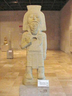
Much of what is known about the Huaxteca, or Huasteca, before the Spanish conquest of Hernán Cortés is because of the work of Dr. Gordon F. Eckholm, who was curator of Mesoamerican (Middle American) archaeology at the American Museum of Natural History from 1937 to 1974. Eckholm began his work on the eastern coast of Mexico in 1941, with the original intention of tracing possible Mesoamerican cultural influences on the southeastern United States.

Although Eckholm later modified his point of view, his fieldwork established that the Huastecans had “developed in a wide area that extends without precise boundaries through the actual states of Tamaulipas, northern Veracruz, San Luis Potosí, Hidalgo, and some parts of Queretaro and Puebla.

Realizing that there were abundant archaeological sites and materials in the region that had been neglected,” Eckholm developed a timeline that showed that the Huastecans had developed a flourishing culture, which began sometime in the early Christian era.

The Huastecans appear to be descended from the Mayans and became isolated in their region around the year 100 by stronger peoples, the Nahuas and the Totonacs. Ake Hultkrantz advanced the thesis in his The Religion of The American Indians that all Mayans, including the Huastecans, “spread from Huehuetenango in northwestern Guatemala, where a corn-farming community was in existence as early as 2600 b.c.e.”


In this enforced exile from their Mayan homeland (possibly among the Mayans of the Yucatán peninsula in Mexico), their language developed its own character. The Mexican archaeologist Lorenzo Ochoa felt that the Huastecans eventually broke out of their insularity and established contacts with the dominant cultures of Mexico.

The Preclassical period of Mexican history is considered to have existed from 2000 b.c.e. to 300 c.e., the Classical period from 300 c.e. to 900 c.e., and the Postclassic from 900 c.e. to 1520 c.e., the year before Cortés crushed the last major indigenous kingdom, the Aztec Empire, thus ending the independent rule of Mexicans.

Some of the Huastecan centers identified by Eckholm were at Las Flores, Tampico, Pánuco, Tuxpan, Tajin, and Tabuco. Unique among cultures like the Toltec, Mayan, and Aztec famed for their use of rectangles and squares, the Huastecans built oval structures, like their temple at Las Flores. Eckholm advanced the thesis that the cult of Quetzalcoatl actually began among the ancient Huastecans.

The Huastecans, as with other Mesoamerican peoples, used the bow and perhaps the sharp obsidian-edged sword used by Aztecs in warfare. Mesoamerican warriors also used the atlatl, or spear-thrower, which was used to add great range to darts that they fired with its aid.

Shields, often brightly covered with bird feathers, were also a common feature among Mesoamerican armies. Hassig observes, “The use of body paint in warfare extended throughout Mesoamerica and was practiced inter alia by Mayans, Tlaxcaltecs, Huaxtec, and Aztecs.” Among the Aztecs at least, wrote Hassig, “the use of special face paint was a sign of martial accomplishment.”

The Aztecs had emerged by the 15th century as not only the dominant warriors of Mexico, but were also renowned for their trading ability. This, of course, evoked jealousy among the other kingdoms of Mexico. The Gulf Coast of Mexico where the Huastecans lived, known to the Aztecs as the “hot lands,” was a natural target for Aztec merchants. In 1458 Huastecans murdered Aztec merchants in Tziccoac and Tuxpan.

In revenge, the Aztec emperor Moctezuma I launched a campaign to punish the Huastecans. It also gave the Aztecs a cause to conquer some of the richest lands in Mexico. As Peter G. Tsouras writes in Warlords of the Ancient Americas, the region produced “cotton, brilliant feathers, and jewels, and ocean products such as various prized shells, and exotic foods like chocolate and vanilla.”

The Huastecans, like the Aztecs, were a warrior people, and the Aztecs were wary of the encounter. For one thing, their military strategists were not familiar with the geography of the Gulf Coast area. To bolster the spirits of the Aztec army, Tsouras notes, on the eve of the battle with the Huastecans, an Aztec captain declared to the soldiers, “Contemplate your death and think of nothing else. You have come here to conquer or die since this is your mission in life.” Moctezuma I decided to leave nothing to chance.

The night before battle some 2,000 of his knights covered themselves up with grass, ready for a massive ambush of the Huastecan army. On the next day, when the Huastecans attacked, Moctezuma’s men bolted and pretended to run away in panic. When the Huastecans followed, shouting for victory, the waiting warriors sprang up and attacked them, defeating them completely.

The Aztecs fought largely to gain prisoners for human sacrifice, not to kill, as did the Spanish. After the victory of Moctezuma, many—if not all—of the Huastecan captives had their hearts cut out by obsidian knives to feed the thirsty gods of the Aztecs.

When Hernán Cortés landed on the gulf coast at what is now Veracruz, it seemed impossible that he would ever achieve his goal of conquering the Aztec Empire. Yet, many of the subjugated peoples, hating the Aztecs for their exorbitant taxation and human sacrifices, joined him in his war. In 1521 the Aztec Empire fell, its last emperor Moctezuma II either stoned to death by his people for appearing to collaborate with the Spanish or garroted by the orders of Cortés.

Southeastern Periphery of Mesoamerica

Southeastern Periphery of Mesoamerica

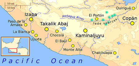
Southeastern Mesoamerica has been so little understood that even the two Mayan sites in the area, Copán and Quirigua, which flowered from the fifth to the ninth centuries, were thought of as the creations of itinerant Mayans rather than having been created by the Mayans indigenous to the region.

However, as Dennis Tedlock, the translator of the Popol Vuh, the holy book of the Quiché Mayans of Guatemala, has noted, the Mayan culture not only embraced Chiapas Province and the Yucatán in Mexico, but also Guatemala, El Salvador, and Honduras. According to Tedlock, “inscriptions on stone monuments [sometimes called stelae] first appeared in the ‘highlands of Chiapas’ in the first century b.c.e.”

Ultimately the inscriptions spread throughout the entire area. While it was believed that the Mayans were essentially a peaceful people, more recent excavations, like that at Bonampak, have shown them to be as warlike as those who followed them, the Toltecs and the Aztecs.


Southeastern Mesoamerica, as noted in the Popol Vuh by Tedlock, became a fertile area for Mayan development. Uaxactún, in the Petén region of Guatemala, became established as a ceremonial center in the first or second centuries, and El Mirador, in northern Guatemala, was founded around the same era.

The term ceremonial center is an ambiguous one in Mesoamerican studies. Although it refers to an archaeological site that was used for religious ceremonies, certainly an urban population had to exist there permanently in order to provide the needed support for ceremonies in accordance with the Mayan calendar.

Contemporary with the Mayans, the Mixtec and Zapotec cultures flourished in the Oaxaca valleys in Mexico, while the great center at Teotihuacán dominated the Mexican highlands. City-states flourished when a particularly strong and talented ruler held sway, much as the golden age of ancient Athens is associated with Pericles.

Mayan civilization was not driven by a great need for centralization, as was later seen with the Aztecs. Instead, Mayans formed city-states like Copán and Tikal, which seemed to be locked in almost perpetual warfare with each other.

A comparison can be made to ancient Greece, with its wars among city-states like Athens and Thebes, and ancient Rome, with the centralization that would produce one of the world’s greatest empires.

With the end of the Classic period, Mayan culture gravitated away from the southeastern periphery of Mesoamerica to the Yucatán peninsula of Mexico.

Chichén Itzá, Uxmal, and Mayapán became the centers of Mayan culture in the Postclassic period, after 900. The civilization and form of government, however, remained virtually unchanged from the heyday of southeastern Mesoamerica.

Individual leaders dominated Mayan city-states. Traditional accounts of Mayan civilization have usually referred to these rulers as priest-kings, since they presided over both affairs of state and religion. However their position in Mayan society was tenuous.

During the Postclassic period, there was peace among Chichén Itzá, Uxmal, and Mayapán for about a century, until in about 1100 Mayapán went on a war of conquest and seized the other two Yucatán Mayan city-states.

For about 200 years Mayapán controlled what may have been the closest political organization to a kingdom that the Mayans evolved. Yet in 1441 Uxmal threw off the rule of Mayapán.

From then on the Mayan city-states became embroiled in a series of civil wars that would only end with the Spanish conquest that followed the arrival of Hernán Cortés in Mexico in 1519.

Postclassic Period of Mesoamerica

Postclassic Period of Mesoamerica

Postclassic Mesoamerica (900–1500 c.e.) encompassed four principal geographic regions: the Maya zones to the south and east; the central highlands, centered on the Basin of Mexico; the Zapotecs of the Oaxaca Valley; and the Mixtec polities in the region north and west of Oaxaca. Sometimes called “The Time of Troubles,” the Postclassic period in these regions was characterized by several broad and overlapping trends.

The most important were political fragmentation and the rise and decline of new polities; a heightened emphasis on militarism, aggression, and violence, accompanied by the political supremacy of an ascendant class of warrior elites; the institutionalization of the practice of human sacrifice; increased movements and migrations of peoples; and the disruption and reconfiguration of regional and long-distance trade and commercial networks.

Toltec

In the Basin of Mexico and the central highlands, the Postclassic period was inaugurated by the decline and collapse of the great city of Teotihuacán around 650; the expansion and contraction of the city-states of Cholula, Xochicalco, and El Tajín; and the subsequent political fragmentation of the region into numerous competing city-states. Around 900 another polity saw a rapid rise to prominence in the central highlands: the Toltecs.


Originating somewhere in the northern deserts, probably around the present-day Mexican state of Zacatecas, the Toltecs were but one of several waves of migrants from the arid northern regions to whom the settled peoples of the central highlands applied the generic name Chichimeca, meaning “lineage of the dog” and connoting both their martial skill and their “barbarism.” The later Aztecs would also be called Chichimeca.

According to Toltec legend, their semidivine founder Mixcóatl (Cloud Serpent) swiftly defeated his adversaries in his inexorable march into the Basin of Mexico, where he established a capital city at Culhuacán.

Mixcóatl’s brother then treacherously assassinated him, after which his pregnant widow fled into exile, where she bore his son, whom she named Ce Acatl Topiltzín (Prince One Reed). As a boy, Topiltzín became a devout follower of Quetzalcoatl (the Plumed Serpent), the principal deity of the former great city of Teotihuacán.

Topiltzín took on Quetzalcoatl’s name to become Topiltzín-Quetzalcoatl; the man-hero slew his uncle (his father’s assassin) and around the year 968 founded a new city in the northern section of the Basin of Mexico, Tula, which would become the capital of the Toltecs.

Topiltzín-Quetzalcoatl, in turn, became the font of all the stunning achievements of the Toltecs, including the cultivation of maize, the invention of writing, the introduction of the ritual calendar, and all of the other attributes of the Toltec civilization.

Meanwhile a power struggle emerged within the Toltec capital of Tula between devotees of the two principal rival gods, Quetzalcoatl and Tezcatlipoca (Smoking Mirror).

Maya Civilization

The latter craftily tricked Topiltzín-Quetzalcoatl into engaging in an incestuous relationship with his sister and forced him into exile in consequence of this disgrace, first to Cholula and then into the Maya region. In this way, according to legend, Tezcatlipoca became the preeminent god of the Toltecs.

A capricious, whimsical deity who reveled in exposing the frailties and pretensions of human beings, Tezcatlipoca was said to require for his propitiation ritual human sacrifice. This is how, according to legend, the practice of human sacrifice arose among the Toltecs.

It is more likely that, as among other polities before and after, ritual human sacrifice emerged as a way for the Toltec ruling classes, particularly its warrior elite, to legitimate and consolidate their dominion and to strike fear into their actual and potential enemies.


The Toltecs ruled a substantial portion of the Basin of Mexico until the mid-1100s, when a combination of drought, famine, and endemic warfare fatally weakened the still-forming polity. By the mid-1100s they had abandoned their capital city of Tula, which became the site from which the later Aztecs claimed direct lineage.

Zapotec

Among the Zapotec-speaking peoples of the Valley of Oaxaca, the decline of Monte Albán between 700 and 900 (the terminal phase of Monte Albán IIIb and the beginning of Phase IV) was followed by political fragmentation and the rise of numerous competing polities.

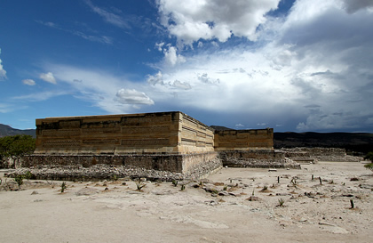
Among the most prominent of these was centered at the ceremonial complex of Mitla, southeast of Monte Albán, where construction began in the early- to mid-900s, around the same time as Tula to the north and west.

The ruins at Mitla have long captured the imagination of archaeologists and visitors, with their elegant lines, precision stonework, and complex geometric ornamentation.

While the palaces and courtyards of Mitla were built in an open area, a nearby fortress testifies to the heightened militarism that characterized the Oaxaca Valley polities long after the site of Monte Albán itself had been largely abandoned and become mainly a site for pilgrimage and ritual.

Scholars have yet to decipher the Zapotec inscriptions that grace the ruins of Monte Albán and other sites in the Oaxaca Valley. It is hypothesized that specific hand gestures represent verbs; that noncalendric glyphs were intended to convey information regarding political, military, and ritual affairs; and that as-yet undiscovered connections exist among Mayan, Zapotec, Mixtec, and Aztec writing systems. Investigations into these and related arenas of Zapotec history continue.

Mixtec

The mountainous zones lying north and west of the Valley of Oaxaca were home to numerous Mixtec (Cloud People) polities that emerged during the Postclassic period.

By the 1200s these Mixtec states had extended their influence south and east into areas traditionally controlled by the Zapotecs—including periodic occupations of Monte Albán and Mitla. The Postclassic Mixtec developed one of the most extreme systems of social stratification in all of pre-Columbian Mesoamerica.

While all Mesoamerican polities placed a high degree of emphasis on purity of lineage, birth order, and elite status, these attributes were especially salient among the Postclassic Mixtec.

For instance inscriptions record at least four cases of full brother-sister marriage among the descendents of the Mixtec lord named Eight Deer— an evident effort to retain purity of lineage.

Among both the Mixtec and Zapotec Postclassic polities, there was little of the elaborate administrative and bureaucratic hierarchy that characterized other states during this period, including the Aztecs. Instead the word of the ruling lord was deemed law, carried out by a second tier of elite lords who ruled subject polities under the main lord’s dominion.

The Aztec state, which emerged in the Basin of Mexico during the middle of the Postclassic period, exhibited all of the principal features characterizing the Postclassic polities of the central and southern highlands, particularly the heightened emphasis on militarism, warfare, human sacrifice, and conquest of lesser polities in the formation of a tributary empire.

Mixtec and Zapotec

Mixtecs
Mixtecs

The Zapotec and Mixtec were groups of Mesoamerican people who inhabited land at different times in the valley of Oaxaca in Mexico. This area lay south of today’s Mexico City on the west coast of the country and was rich in natural and cultural resources.

Monte Albán was one of the first cities in the New World. Now a ruin, it once served as a magnificent ceremonial site with ball courts, plazas, tunnels, tombs, and buildings. Archaeologists have evidence that these people knew about irrigation because there are terraces to allow spring water to flow down and maintain their crops.

As other Mesoamerican groups they practiced ritual human sacrifice. The ceremonies were complex, using obsidian knives to cut out the beating heart of the victim from on top of a pyramid.


Tombs have been excavated where the remains of kings and priests were buried with ornate grave goods, some with precious metals. Monte Albán was ideal as a ceremonial center because it was near the juncture where three arms of the Oaxaca Valley met.

The time periods of these cultures are defined in terms of Mesoamerican chronology. The Formative is divided into three groups: Early, Middle, and Late (300 b.c.e.–150 c.e.) and the Classic into four: Early (150–650 c.e.), Late Classic (650–900 c.e.), Early Postclassic (900–1200 c.e.), and Late Postclassic (1200–1521 c.e.). The Zapotec and Mixtec occupied Mexico’s valley of Oaxaca from the Late Formative to the Late Postclassic period.

The Zapotec

Early Zapotecs lived during the Middle Formative period (Preclassic period) 500–400 b.c.e. One of the first pieces of archaeological evidence found was a gruesome message in the form of carvings on stelae (stone monuments).

It was a bas-relief (raised carving) of a dead man, stripped of all clothing with blood coming out of his chest and some scrolls with glyphs (decorative writing) between his legs. He probably represented an enemy who had been sacrificed.

The style of art, known as Danzantes, or dancers, is unique to the Zapotec culture, and typical for that time period. The style differs from other Mesoamerican art because the human figures are curved, not angular, without clothing, body decoration, or jewelry.

Zapotec
Zapotec

They are shown in active rather than in posed-type positions that were characteristic of rulers from other time periods. These dire figures are captives, in agony because they have been ritually tortured and are being sacrificed.

Their eyes are closed, their tongues are protruding, and their hands and feet are limp. It is thought that they represent high-level individuals who were killed by other rulers because they are depicted as old, with beards and without teeth.

The glyphs, combination of phonetic symbols, numbers, and ideographic elements, were the first in Mexico. The Zapotec had a calendar based on a 260-day year and a 52-year cycle. Their pottery included spouts or hollow three-legged bowls fashioned from fine gray clay. It is estimated that this early Monte Albán I culture supported a population of about 10,000 to 20,000.


From about 200 b.c.e. to 250 c.e. (Early Classic period), the Zapotecs lived in relative harmony and comfort. A few new buildings were constructed. One of them might have been an observatory because it was oriented in the direction of a bright star known as Capella.

Another building (referred to as building J) has many narrow dark hallways that connect at a common apex. On the outside, there are more typical glyphs with elaborate headdresses, but they have closed eyes.

It is believed that these heads and symbols represent both date notations and records of victory over neighboring enemies when a particular town was attacked and conquered. Older cultures often documented wars in this way.

Although contact with the Maya was evident in elements from Mayan art incorporated in their pottery, in the Classic period, there was more influence from Teotihuacán, the gigantic complex northeast of Oaxaca. The Zapotec continued to build terraces and maintained their Zapotec language, which remained dominant.

They had a lively pantheon: the rain god, Cocijo; the maize (corn) god, Pitao Cozobi; a feathered serpent; a bat god; a fire god; and a water goddess. The Zapotec thrived in Monte Albán until about 700 b.c.e., at which time they abandoned the site, probably because of new invaders from the northwest.

The Zapotec moved 25 miles southwest of Oaxaca to an area called Mitla, from the Nahuatl word Mictlan, which means Place of the Dead. However, they called it Lyobaa, Place of Rest. They built five palatial buildings, guarded by a fort on a strategic hill.

These buildings still stand; unfortunately after European contact, the church destroyed and replaced indigenous religious structures. A colonial period church was built right on top of one of these structures.

The Mixtec

Mixtec ruin
Mixtec ruin

Mixtec comes from an Aztec word that means Place of the Clouds, but the people, the Mixe, used the word Ayuk to describe themselves. It meant “word” or “language,” a word related to ha”yyu:k, “people of the mountains.”

They are best known for their elegant books called codices in which they drew figures that resembled cartoons. These deerskin books unfolded to form a long strip, which could be read phonetically. Eight Mixtec codices have survived from before the conquest.

Around 850, during the Early Classic period, the Mixtecs lived in hilltop settlements of northwestern Oaxaca. During the Postclassic, around 1000, they moved into adjacent areas and then down to the valley of Oaxaca because they felt that Monte Albán was safe from invaders.

The Mixtec’s best-known cities were Tilantongo and Teozacualco. They had superb artistic skills in carving, metalworking, painting, and silversmithing. There is a life-sized skull fashioned from a huge piece of quartz, which is Mixtec in origin, on display in the Inah Anthropology Museum in Mexico City.

The huge centers built by the Mixtec were primarily residential. Everyday activities took place on the valley floor but the hilltops were reserved for ceremonial sites. By the Postclassic period, most of the prior Zapotec territory was under their control. Their success is attributed to the way in which they organized social groups and interacted with others.

The heredity ruling class (caciques) were the highest; next were a hereditary noble (tay toho), a working class (macehuales), and in certain areas, a servant-tenant class (terrazgueros) that could be compared to the European feudal serf in status.

As in any hierarchy the upper strata had privilege and power, hence more than one wife and control of natural resources, although gender did not play a strong part in social structure. Bilateral kinship lines determined lineage, which was more important to the Mixtec. Macehuale women as well as men could own land.

Their language had unique symbols representing sounds as compared to other written languages that used glyphs and rebuses to communicate. The names of animals figured prominently in titles of their rulers such as Eight Deer, Three Alligator, Four Tiger, or Jaguar Claw because of their symbolic significance.

Births, deaths, marriages, and land conquests are documented. Rank, occupation, and social status were defined by special ornamentation. The best known and powerful ruler, Eight Deer, had five wives, and his life is elaborately documented in the Codex Nuttal.

By 1350 c.e. the Mixtec had intermarried and taken control of the Zapotec sites. At the time of the conquest, great wealth and high culture abounded. Tombs attested to kings with their courts buried with gold, silver, turquoise, amber, coral, pearls, and carved jaguar bones. Unconquerable by their neighbors, they survived until the Europeans arrived.

Quetzalcoatl


Quetzalcoatl evokes one of the great tales of Middle American (Mesoamerican) mythology. In Nahuatl, the language of the Aztecs of Mexico, the name Quetzalcoatl can be translated as “feathered serpent.” There is in fact a quetzal bird, prized for its plumage and highly priced on the international bird market.

However the figure of Quetzalcoatl is not just confined to Mexico, where the Spanish under Hernán Cortés overwhelmed the Aztecs in 1521. The Maya of Mexico’s Yucatán Peninsula know Quetzalcoatl as Kukulcán, and their cousins the Quiché Maya of Guatemala know Quetzalcoatl as Gugumatz.

There are three main interpretations to this profound myth. They are that Quetzalcoatl appears as the creator god, a civilizer coming from the east, and the last king of the Toltecs, the greatest warrior race in Mexico, before the advent of the Aztecs in Mexico in about 1100.


The Codex Vaticano, one of the few surviving Aztec documents (most were destroyed by zealous Spanish priests and friars), remarks that the supreme god Tonacatecutli created Quetzalcoatl.

The description of Quetzalcoatl is remarkably similar to that of the story of Christ in the New Testament, and one cannot discount that fact the friars or priests may have added to the Codex Vaticano their own interpretation in order to make Christianity more palatable to the Aztec people.

Quetzalcoatl depicted as feathered serpent

The Codex Vaticano notes that Quetzalcoatl was “sent as an ambassador and announced this to a [virgin, much like the visit of the archangel Gabriel to Mary, announcing she would give birth to Jesus] in Tula. He said that he was sent to save the world with penance [for the people] since his father had created the world but all humanity had fallen into sin. And that Tonacatecutli (known also by the name of Citinatonali) had sent his son to save the world.”

The idea of god-kings was as common among the Aztecs and Mayas as it had been earlier with the Egyptians and their pharaohs. Therefore the people of Middle America very easily accepted the idea that Quetzalcoatl could become king of Tula, a Toltec city. The Aztec emperors presided over the massive human sacrifices of their empire as the direct representative of the people with their gods.

Mayan god-kings would shed their own blood by passing thorny twigs through their tongues in order to connect their people to the earth and the gods in the heavens by the sacrifice of their own blood. In Yucatán the pyramid dedicated to Quetzalcoatl, or Kukulcán, at the sacred site of Chichen Itza dominates the landscape.


The most intriguing part of the legend of Quetzalcoatl is its ending. The people and priests turned against their god-king because of his attempts at reformation. Most of all, Quetzalcoatl had forbidden the practice of human sacrifice. (In the legends, he appears as a tall, white man, much different from the Indians of Middle America.) In the end his own people force him into exile and he leaves across the ocean to the east on a raft of his serpents, promising to return.

When Hernán Cortés arrived at what is now Veracruz in Mexico in 1519, Moctezuma II’s scouts rapidly bore word of the appearance of this strange man—a white man—from the east. Moctezuma may have been reluctant to use force against the small band of Spanish adventurers because he thought that Cortés was Quetzalcoatl.